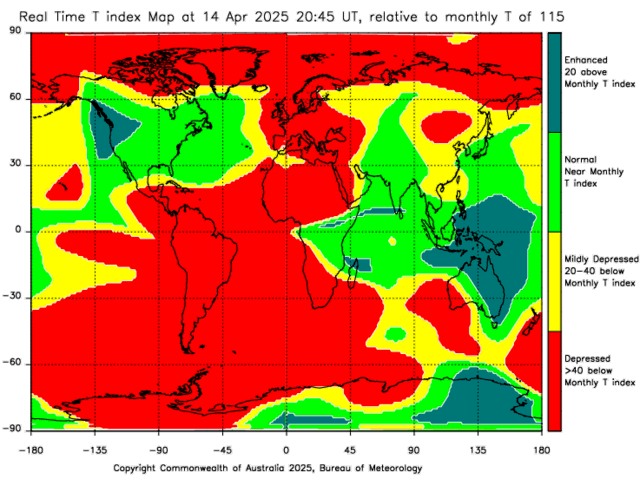

"A map showing the difference between current observed hourly conditions and predicted monthly conditions for the global ionosphere. Depressions and enhancements are with respect to the Space Weather Services (SWS) predicted monthly T-Index for that month.
Note: The foF2 values used in the T-Index mapping process are based on the median of the last 2 hours of station data. This may mean that the map may lag actual ionospheric behavior, particularly after local dawn." Source: Australian Government - Bureau of Meteorology, Space Weather Services
Note: Refresh/reload this web page to download the latest data.

Source: Australian Government - Bureau of Meteorology, Space Weather Services
"A table of observed and predicted values for the SWS T-Index. The T-Index is a measure of the behavior of the F-layer of the ionosphere and is used as an input for the SWS HF frequency prediction program ASAPS."

Source: Australian Government - Bureau of Meteorology, Space Weather Services
"The T-Index is calculated from the vertical MUF (foF2) obtained from SWS ionograms combined with the SWS world map grid point data. The grid point data form the SWS world maps of foF2, there are 576 maps, for two ionosheric levels (T=0, T=100), 12 months, and 24 hours.
An foF2 observation can be converted into a T-Index by interpolation/extrapolation of the line obtained from the maps at a geographic location i.e. two map T, foF2 value pairs and the observed foF2, then read off the corresponding T-value. The T-Index is predicted over a coming solar cycle to provide a long term ionospheric index trend for HF communicators." Source: Australian Government - Bureau of Meteorology, Space Weather Services
Source: Space Weather at South African National Space Agency (SANSA)
Note: Refresh/reload this web page to download the latest data.


Antenna's